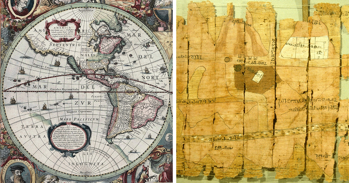
Before GPS politely told us to “make a U-turn when possible,” humans had mapsbeautiful, confusing, brilliant, occasionally wrong maps. Ancient maps of the world were not just pretty drawings on parchment, clay, silk, vellum, or paper. They were survival tools, political statements, trade guides, spiritual diagrams, and early attempts to answer the biggest travel question of all: “Where exactly are we, and how do we get to the place with spices?”
The story of ancient world maps is the story of people trying to shrink the planet into something the human mind could hold. Sailors used coastal charts to avoid shipwrecks. Merchants used route maps to move goods across deserts and seas. Scholars used mathematical geography to measure the known world. Rulers used maps to claim territory, impress rivals, and occasionally pretend they knew more than they did. In short, maps were Google Maps, political propaganda, travel blog, and bragging rightsrolled into one.
This guide explores 47 ancient maps and map traditions that shaped navigation, geography, exploration, and the way civilizations imagined the world. Some were practical nautical charts. Others were symbolic worldviews. All of them mattered.
Why Ancient Maps Were More Than Decoration
Modern readers often laugh at ancient maps because coastlines wobble, monsters appear in oceans, and continents sometimes look as though they were drawn after a rough lunch. But judging ancient cartography by satellite standards misses the point. These maps were built from sailor reports, astronomy, mathematics, religious belief, trade routes, military needs, and stories carried from port to port.
A map did not need perfect longitude to be useful. A medieval portolan chart, for example, could guide sailors along Mediterranean coastlines with impressive practicality. A Roman road map could help travelers understand routes, stops, and distances even if it distorted physical geography. A Ptolemaic world map could organize thousands of place names into a coordinate system, giving later mapmakers a framework to improve.
Ancient maps were tools of movement. They told people where to sail, where to trade, where empires ended, where danger began, and where imagination had to fill the blank spaces.
47 Ancient Maps Of The World That Changed Navigation
1. The Babylonian Map of the World
Often called one of the earliest known world maps, the Babylonian Map of the World was carved on a clay tablet. It shows Babylon near the center, surrounded by lands and a circular ocean. It was not a sailor’s chart, but it reveals how ancient Mesopotamians organized geography, myth, and power into a single worldview.
2. Egyptian Route Maps
Ancient Egyptian maps helped organize expeditions, mining routes, and sacred landscapes. The famous Turin Papyrus Map, often associated with quarrying and mining routes, shows that practical mapping existed long before printed atlases. It was less “vacation brochure” and more “please do not get lost in the desert.”
3. Anaximander’s World Map
The Greek thinker Anaximander is traditionally credited with creating one of the earliest Greek world maps. Though the original does not survive, his work represents a major intellectual leap: the world could be studied, drawn, and debated as a physical space rather than only described in myth.
4. Hecataeus’ Map
Hecataeus of Miletus refined earlier Greek geographic ideas, dividing the known world into Europe, Asia, and Libya, meaning Africa. His map tradition helped turn travel knowledge into organized geography.
5. Eratosthenes’ World Map
Eratosthenes famously calculated Earth’s circumference with remarkable insight. His map divided the known world using lines similar to latitude and longitude, proving that geography could be measured, not merely guessed with dramatic confidence.
6. Strabo’s Geographic Worldview
Strabo’s geography preserved descriptions of lands, peoples, distances, and routes across the ancient world. While not a single surviving map in the modern sense, his geographic framework deeply influenced how later scholars understood the inhabited world.
7. Pomponius Mela’s World Map Tradition
Roman geographer Pomponius Mela described the world in zones and regions. His work reflected ancient attempts to connect climate, geography, and navigation into a structured global picture.
8. Ptolemy’s World Map
Claudius Ptolemy’s Geography became one of the most influential works in cartographic history. His system used latitude and longitude to organize thousands of locations. Even where his data was wrong, his method was revolutionary.
9. Ptolemaic Regional Maps
The regional maps derived from Ptolemy’s Geography helped scholars and travelers break the known world into manageable sections. These maps later influenced Renaissance cartographers, who treated Ptolemy like the ancient professor everyone still had to cite.
10. The Peutinger Table
The Peutinger Table is a Roman road map tradition showing routes, cities, and stations across the empire. It stretches geography into a long ribbon, prioritizing travel information over accurate shapes. For road navigation, that made perfect sense.
11. Chinese Silk Maps
Ancient Chinese silk maps, including examples from the Han period, show military, administrative, and topographic information. These maps demonstrate a sophisticated tradition of mapping terrain, routes, and strategic places.
12. Yu Ji Tu, The Map of the Tracks of Yu
This Chinese stone map used a grid system and reflected advanced geographic thinking. It showed rivers, coastlines, and administrative space with notable accuracy for its time.
13. The Kangnido Map
Created in Korea in the early 15th century, the Kangnido map combined Chinese, Korean, Japanese, and Islamic geographic knowledge. It is one of the great examples of cross-cultural cartography before European oceanic expansion transformed world maps.
14. Al-Idrisi’s Tabula Rogeriana
Made for King Roger II of Sicily, Al-Idrisi’s 12th-century world map and geographic text drew from Islamic, classical, and traveler knowledge. It was practical, detailed, and remarkably ambitious.
15. Islamic Qibla Maps
Qibla maps helped Muslims determine the direction of Mecca. They combined geography, astronomy, and religious practice, proving that navigation was not only about ships and trade but also daily orientation.
16. The Balkhi School Maps
Medieval Islamic cartographers associated with the Balkhi tradition created schematic maps of regions and routes. These maps emphasized clarity, networks, and useful geographic relationships.
17. The Hereford Mappa Mundi
The Hereford Mappa Mundi is a medieval Christian world map filled with cities, biblical scenes, animals, and legends. It was not designed for steering a ship, but it navigated the spiritual and historical imagination of medieval Europe.
18. The Ebstorf Map
The Ebstorf Map, known from historical records and copies after its destruction, showed the world through a Christian symbolic framework. It placed geography inside a theological story, where orientation meant meaning as much as direction.
19. The Psalter Map
This small medieval world map compressed geography and belief into a compact visual form. It shows how portable maps could serve education, devotion, and cultural memory.
20. The Cotton Map
The Anglo-Saxon Cotton Map is one of the earliest surviving maps from medieval England. It reflects how geography, classical learning, and regional identity were combined in manuscript culture.
21. The Tabula Peutingeriana Copies
Medieval copies of Roman route mapping preserved the idea that maps could function like travel instructions. The result looks odd to modern eyes, but for movement across roads, it was wonderfully direct.
22. The Carta Pisana
The Carta Pisana is often described as one of the earliest surviving portolan charts. Its dense coastal names and rhumb lines show a new maritime focus: sailors needed coastlines, ports, and bearings more than decorative mountains.
23. Majorcan Portolan Charts
The Majorcan school of cartography produced richly detailed portolan charts. These maps combined navigation lines, coastal information, flags, rulers, and inland decoration. They were practical tools with artistic swagger.
24. Pietro Vesconte’s Charts
Pietro Vesconte was among the major early makers of portolan charts and atlases. His work helped standardize nautical mapping in the Mediterranean and influenced later mapmakers.
25. Angelino Dulcert’s Portolan Chart
Dulcert’s 14th-century chart is a landmark in medieval maritime cartography. It shows the Mediterranean, Atlantic coasts, and inland information, blending sailing utility with geographic curiosity.
26. The Catalan Atlas
The Catalan Atlas, associated with Abraham Cresques, is one of the most famous medieval maps. It includes trade routes, rulers, cities, and Asia’s legendary wealth. For merchants and travelers, it was part map, part intelligence report.
27. The Medici Atlas
The Medici Atlas preserved portolan-style maritime knowledge and expanded European awareness of Atlantic and African coasts. It belongs to the practical world of sailing, trade, and exploration.
28. The Genoese World Map
The Genoese World Map of the 15th century combined medieval traditions with growing knowledge of Africa and Asia. It shows a world in transition, where older ideas and new travel reports competed for space.
29. The Fra Mauro Map
Fra Mauro’s 15th-century world map is one of the masterpieces of medieval cartography. Based in Venice, Fra Mauro gathered information from travelers, merchants, and nautical sources. The result was a vast, detailed world picture that treated the Indian Ocean and Africa with unusual seriousness.
30. The Bianco World Map
Andrea Bianco’s maps and charts contributed to 15th-century navigation by preserving portolan knowledge and broader world geography. His work reflects Venice’s deep connection to maritime trade.
31. The Walsperger Map
The Walsperger Map mixed medieval religious geography with newer cartographic information. It reminds us that maps often carry two compasses: one pointing to places, the other pointing to beliefs.
32. The Martellus World Map
Henricus Martellus’ late 15th-century world map is especially important because it may have influenced Christopher Columbus. It represented the known world just before Europeans realized the Atlantic concealed continents that would change every mapmaker’s workload forever.
33. The Behaim Globe
Martin Behaim’s globe, made before Columbus returned from the Americas, shows a European view of the world on the eve of major Atlantic discoveries. It is a globe, not a flat map, but its navigational importance is enormous.
34. The Cantino Planisphere
The Cantino Planisphere captured Portuguese geographic knowledge around 1502. It shows discoveries in Africa, Brazil, and the Indian Ocean, making it one of the great intelligence documents of the Age of Exploration.
35. The Caverio Map
The Caverio Map helped transmit Portuguese discoveries into broader European cartography. It influenced later maps, including the famous Waldseemüller map.
36. The Waldseemüller Map
Martin Waldseemüller’s 1507 world map is famous for using the name “America.” More importantly, it helped redefine the world by showing the New World as separate from Asia. That is a major upgrade from “maybe this is just more Asia.”
37. Waldseemüller Globe Gores
Waldseemüller also created printed globe gores, designed to be cut and pasted onto a sphere. These turned new geographic knowledge into a three-dimensional educational and navigational object.
38. The Ruysch World Map
Johannes Ruysch’s 1507 map incorporated discoveries from Atlantic exploration and appeared in editions of Ptolemy. It shows how printed maps quickly absorbed new travel information.
39. The Miller Atlas
The Miller Atlas is a richly decorated Portuguese atlas from the early 16th century. It presents coastlines, trade knowledge, and maritime power in spectacular visual form.
40. The Piri Reis Map
The Piri Reis Map, created by an Ottoman admiral, is famous for its depiction of Atlantic coasts. It drew from multiple sources and reflects the global circulation of maritime intelligence.
41. The Ribeiro World Map
Diogo Ribeiro’s 16th-century maps incorporated Spanish and Portuguese exploration data. They were essential to disputes about oceans, empires, and who got to claim what after sailing there first.
42. Battista Agnese Portolan Atlases
Battista Agnese produced elegant manuscript atlases in the 16th century. His maps often showed routes across oceans and were prized by wealthy patrons interested in navigation and exploration.
43. Sebastian Münster’s Ptolemaic Maps
Münster’s editions of Ptolemy helped spread classical geography through print. His work shows how ancient mapping systems were repackaged for Renaissance readers hungry for world knowledge.
44. Mercator’s World Map
Gerardus Mercator’s 1569 world map introduced a projection that became famous for marine navigation because it represented constant compass bearings as straight lines. Sailors appreciated that. Continents near the poles became oversized, but every map has trade-offs.
45. Ortelius’ Theatrum Orbis Terrarum
Abraham Ortelius published what is often called the first modern atlas in 1570. By collecting maps in a consistent format, he made geographic knowledge easier to compare, study, and use.
46. Urbano Monte’s World Map
Urbano Monte’s massive 1587 world map is one of the most ambitious early modern attempts to visualize the globe. Its enormous scale reflects the growing appetite for comprehensive global geography.
47. Early Nautical Charts of the Atlantic and Indian Ocean
By the 15th and 16th centuries, nautical charts expanded beyond the Mediterranean into the Atlantic, African coasts, Brazil, and the Indian Ocean. These maps were tools of trade, empire, and survival, guiding ships through a world that was becoming more connected every decade.
How Ancient Maps Helped People Navigate
Ancient navigation depended on layers of knowledge. A sailor might use a portolan chart for coastlines, a compass for direction, stars for latitude, experience for currents, and prayer for everything else. Maps did not work alone. They were part of a navigation toolkit that included instruments, memory, pilot books, seasonal winds, and local guides.
Portolan charts were especially important because they focused on what sailors needed most: ports, coastal outlines, distances, and directional lines. Unlike symbolic world maps, portolans were practical. They did not waste much space explaining inland kingdoms when the ship was trying not to hit rocks.
World maps, meanwhile, helped scholars and rulers understand the larger structure of the Earth. Ptolemy’s coordinates, Islamic geographic texts, Chinese grid maps, and Renaissance printed maps all contributed to the gradual improvement of global navigation. Each map was a correction, a conversation, or sometimes a confident mistake waiting for a later cartographer to fix it.
What These Maps Reveal About Human Curiosity
The most fascinating thing about ancient maps is not that they were imperfect. It is that they were brave. They attempted to draw the unknown with limited tools and incomplete information. They collected sailor gossip, merchant reports, astronomical observations, political ambition, and religious imagination, then turned all of that into lines.
These maps also remind us that geography is never neutral. A map’s center tells you who made it. Its blank spaces tell you what they did not know. Its monsters tell you where fear lived. Its trade routes tell you where money flowed. Its errors tell you how knowledge traveled.
Experiences Related To Ancient Maps And Navigation Tools
Spending time with ancient maps is a strangely humbling experience. At first, you notice the beauty: the elegant lettering, the compass roses, the tiny ships, the painted mountains, the golden cities, and the occasional sea creature looking far too pleased with itself. Then you notice the confidence. These maps speak with authority even when they are wrong, which is both charming and very human.
Looking at an ancient world map feels like standing beside someone from another century and asking, “What did the world look like from your window?” The answer changes depending on the map. On a Babylonian tablet, the world is centered around Babylon. On a medieval mappa mundi, geography becomes a sacred story. On a portolan chart, the coastline suddenly becomes urgent and practical. On a Renaissance planisphere, the globe opens wider, and you can almost hear the printing presses, shipyards, and royal courts buzzing in the background.
One of the most memorable experiences is comparing a decorative world map with a practical nautical chart. A mappa mundi may be visually dramatic, packed with symbols and stories. It tells you what the world means. A portolan chart tells you how to survive it. The difference is like comparing a philosophical essay with a boat manual. Both matter, but only one helps when waves are slapping the hull and the captain is shouting about wind direction.
Ancient maps also create a powerful sense of patience. Today, we expect maps to load instantly, reroute automatically, and warn us about traffic jams caused by three bored pigeons and a delivery truck. Ancient navigators had no such luxury. Their maps were copied by hand, corrected slowly, and protected like treasure. A good chart could mean safe arrival, commercial profit, or military advantage. Bad information could mean delay, loss, or disaster.
There is also a thrill in seeing how knowledge moved. A place name might travel from a sailor’s memory to a merchant’s report, then to a manuscript, then to a printed map, then to another mapmaker’s workshop. Ancient maps were not isolated objects. They were social networks before social networksexcept with more ink and fewer arguments in comment sections.
For writers, historians, travelers, and map lovers, ancient maps teach a lasting lesson: every journey begins with an idea of space. The better the map, the better the journey. But even flawed maps have value because they show how people tried to understand their world with the tools they had. They remind us that exploration is not only about reaching new places. It is also about improving the picture in our minds.
That may be the real magic of ancient cartography. These maps are not just old navigation tools. They are records of curiosity. They show humanity leaning over the edge of the known world, squinting into the distance, and saying, “Let’s draw what we know, guess carefully at what we don’t, and hope the sea monster is decorative.”
Conclusion
Ancient maps of the world were paramount navigation tools because they turned uncertainty into usable knowledge. From clay tablets and Roman route maps to Ptolemaic coordinates, Islamic world maps, Chinese grids, portolan charts, and Renaissance atlases, each map helped people move through physical space and intellectual history.
They guided sailors, informed merchants, educated scholars, served rulers, and reshaped humanity’s understanding of the planet. Some were accurate enough to steer ships. Others were symbolic enough to steer civilizations. Together, these 47 ancient maps and map traditions prove that cartography is not just about where places are. It is about how people imagine, measure, and master the world around them.