Editorial note: This article is based on publicly available reporting, official open-source intelligence context, commercial satellite imagery analysis, and defense research. It does not include classified information.
A Missile Launch, a Satellite Pass, and One Very Lucky Screenshot
Every now and then, modern intelligence work delivers a scene that feels like it was written by a screenwriter with too much coffee: a Russian warship fires a missile, a civilian satellite happens to pass overhead at just the right moment, and an open-source analyst notices the tiny flash of history hiding in a public image. No trench coat. No secret basement. No dramatic music. Just pixels, patience, and a surprisingly nosy satellite.
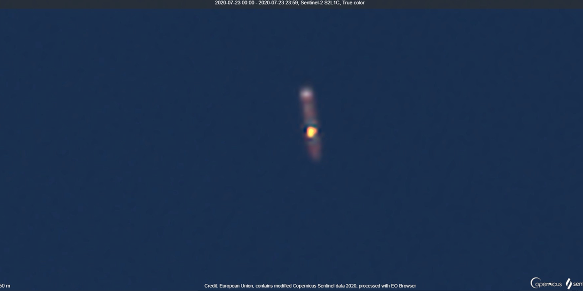
The case behind the headline “Civilian Satellite Spots Russian Missile Test – OSINT News” centers on a rare satellite capture of the Russian Navy destroyer Severomorsk launching an SA-N-9 Gauntlet air-defense missile, also known by its Russian naval designation as the 3K95 Kinzhal. The image was identified by open-source defense analyst Frank Bottema using imagery available through Sentinel Hub. What made the moment remarkable was not simply that a Russian vessel conducted a missile exercise. Militaries do that all the time. The remarkable part was that the launch itselfa blink-and-you-miss-it burst of flame and exhaustwas caught by civilian-accessible satellite imagery.
For open-source intelligence, or OSINT, this was more than a fun “gotcha” moment. It was a neat demonstration of how much the information environment has changed. Once upon a time, satellite imagery was the exclusive playground of governments with very large budgets and very serious buildings. Today, researchers, journalists, hobbyists, and analysts can examine public or commercial Earth-observation data and spot activity that used to disappear behind the curtain of official secrecy. The curtain is still there, of course. It is just full of tiny holes now.
What Actually Happened?
The Russian destroyer Severomorsk, an Udaloy-class anti-submarine destroyer assigned to Russia’s Northern Fleet, was reportedly conducting an air-defense exercise in the Arctic region. During that activity, the ship launched a vertically fired SA-N-9 Gauntlet missile from its aft missile-launch area. In the satellite image, analysts could identify a bright flash near the launcher position and a darker ring of rocket motor exhaust spreading around the ship.
That may sound easy until you remember how fast missile launches happen. A tactical surface-to-air missile does not politely hover for the camera like a tourist at the Grand Canyon. It leaves the launcher in seconds. A satellite in low Earth orbit also has its own schedule, passing over a location briefly before continuing around the planet. For a satellite sensor to capture the exact instant of launch, the timing has to be absurdly luckylike catching a hummingbird sneeze with a disposable camera.
Still, luck alone does not create OSINT. Someone has to know where to look, what to look for, and how to compare the image against other evidence. In this case, the visible launch signature was matched against the ship’s layout, known weapons systems, the date of the exercise, and Russian military announcements. That is the basic OSINT recipe: one part imagery, one part context, two parts verification, and absolutely no seasoning with wild speculation.
Meet the Missile: SA-N-9 Gauntlet, or 3K95 Kinzhal
The missile involved was not an intercontinental ballistic missile or a strategic nuclear weapon. That distinction matters. The SA-N-9 Gauntlet is a naval surface-to-air missile system based on the land-based Tor air-defense family. Its purpose is defensive: to protect ships against aircraft, anti-ship missiles, and other aerial threats at low to medium altitude. On ships such as the Udaloy-class destroyers, the system is launched vertically from deck-mounted cells.
The Russian name “Kinzhal” can create confusion because Russia also uses the name for its Kh-47M2 Kinzhal hypersonic air-launched ballistic missile. Same word, very different weapon. One is a shipborne air-defense system designed to swat airborne threats. The other is a long-range strike weapon. In the great cluttered garage of Russian military nomenclature, someone clearly owns several labels and refuses to buy new ones.
The SA-N-9’s role aboard Severomorsk is part of a layered naval defense system. A ship like this must defend itself from aircraft and incoming missiles while also performing anti-submarine and escort missions. A vertical launch system allows a missile to rise from the ship and then turn toward its target, giving the vessel flexible engagement coverage. In satellite imagery, that vertical-launch moment can appear as a bright thermal or visual flash, depending on the sensor and viewing conditions.
Why Civilian Satellite Imagery Matters
The word “civilian” is doing a lot of work here. It does not mean the satellite is casual, harmless, or taking selfies from space. It means the imagery is available outside classified government channels. That can include free public systems, such as Sentinel-2, and commercial providers that sell higher-resolution data to governments, companies, researchers, and media organizations.
Sentinel-2, part of Europe’s Copernicus Earth-observation program, provides multispectral imagery used for agriculture, disaster response, environmental monitoring, urban planning, and countless other peaceful purposes. But the same characteristics that make it useful for tracking crops and wildfiresrepeat coverage, broad swaths, visible and infrared bands, and public accessibilityalso make it valuable for OSINT work. A satellite does not know whether it is imaging a wheat field, a ship, or a military exercise. It simply records what is below.
This is why open-source analysts spend so much time browsing satellite platforms, comparing dates, checking cloud cover, and staring at pixels until their eyes start negotiating for better working conditions. A single image rarely tells the whole story. But when combined with ship-tracking clues, official statements, terrain features, weather data, social media posts, and known equipment layouts, it can become a powerful piece of evidence.
OSINT: Intelligence Without the Spy Movie Wardrobe
Open-source intelligence is intelligence derived from publicly or commercially available information. It can include satellite imagery, videos, social media posts, ship and aircraft tracking data, government records, academic research, news reports, and commercial databases. The key word is not “open.” The key word is “intelligence.” OSINT is not just Googling things enthusiastically. It requires collection, verification, analysis, and judgment.
The Russian missile-launch image shows the OSINT workflow in miniature. First, an analyst identifies a possible event in imagery. Second, the analyst checks whether the visible object matches a known platformin this case, the Severomorsk. Third, the analyst compares the image to known ship design, launcher placement, and exercise timing. Fourth, the finding is shared publicly, where other analysts can challenge, refine, or corroborate it. That public peer-review process can be messy, but it is also one of OSINT’s strengths. Bad claims do not always survive contact with a thousand skeptical map nerds.
Why This Capture Was So Rare
Missile launches are short-lived. Earth-observation satellites revisit locations on fixed schedules, and many do not image every place continuously. Clouds, darkness, sensor resolution, viewing angle, and timing all matter. Even if a satellite passes over a military exercise, the sensor may capture the scene before or after the interesting moment. In this case, the timing lined up beautifully.
There is also the issue of scale. A destroyer is large by human standards, but from orbit it is a compact object on a huge ocean surface. A missile plume is smaller still. Analysts must distinguish between a real launch signature and ordinary visual noise: sun glint, cloud shadows, ship wakes, smoke, compression artifacts, or sensor quirks. OSINT is exciting, yes, but it is also a discipline where “that weird blob” is not automatically a missile. Sometimes the weird blob is just a weird blob, living its best blob life.
From Severomorsk to Sarmat: A Broader Satellite Intelligence Pattern
The Severomorsk episode is not the only example of satellite imagery exposing Russian missile-related activity. In 2024, commercial satellite images of the Plesetsk Cosmodrome suggested a major failure involving Russia’s RS-28 Sarmat intercontinental ballistic missile program. Analysts pointed to a large crater and visible damage at a launch silo, indicating that something had gone badly wrong. Unlike the naval SA-N-9 launch, the Sarmat case involved a strategic missile system and a suspected catastrophic test failure.
These two examples should not be mixed together, but they belong to the same larger story: satellite imagery has become a public accountability tool. The Severomorsk image captured a fleeting launch event. The Sarmat imagery captured aftermathdamage, cratering, and change over time. One was a lucky snapshot. The other was a before-and-after investigation. Both demonstrate that military events are harder to hide when commercial and public satellites are constantly refreshing the planet’s photo album.
How Analysts Verify a Missile Test From Space
1. They Start With Location
Location is the foundation. Analysts first determine where the ship, launch site, or facility appears. In a maritime case, this can involve coastline references, exercise zones, naval operating areas, or ship movements. In a land-based case, analysts compare the site to known launch pads, silos, roads, support buildings, and exclusion zones.
2. They Compare Before and After Imagery
Change detection is OSINT’s favorite party trick. Analysts compare imagery from different dates to identify new burn marks, disturbed ground, vehicle movement, construction, debris, or blast damage. In the Severomorsk case, the key evidence was the launch flash and smoke. In the Sarmat case, the evidence was damage visible after the suspected incident.
3. They Match Equipment to Known Capabilities
A missile signature means more when it appears exactly where a known launcher is located. The SA-N-9 launchers aboard Udaloy-class destroyers are positioned in a way that helped analysts interpret the flash. Similarly, a crater at a known Sarmat-related silo carries more meaning than a random hole in the woods.
4. They Seek Corroboration
Good OSINT does not trust one image too much. Analysts compare satellite data with press releases, weather reports, vessel information, videos, radar data, official silence, and expert commentary. In defense analysis, silence can be interesting, but it is not proof by itself. A claim becomes stronger when independent pieces point in the same direction.
Why This Matters for Russia, NATO, and the Public
For Russia, public satellite monitoring complicates messaging. A military can announce a successful exercise, avoid discussing a failed test, or release carefully edited footage. But open imagery can reveal details that official statements leave out. It may not expose everything, but it can challenge narratives and force governments to account for visible facts.
For NATO and Western analysts, public imagery provides a shared evidence base. Governments still rely on classified intelligence, but unclassified imagery allows journalists, think tanks, and the public to discuss events without revealing sensitive sources and methods. This has become especially important during the Russia-Ukraine war, where commercial satellite images have documented troop buildups, convoy movements, damage to infrastructure, and possible war crimes.
For ordinary readers, the lesson is simple: modern conflict is increasingly visible. Not completely visible, not perfectly visible, and definitely not instantly understandablebut visible enough that a curious civilian with the right tools can contribute to the public record. That is a major shift in how military power is observed and debated.
The Limits of OSINT: Pixels Are Not Magic
OSINT is powerful, but it is not a wizard in a hoodie. Satellite images can be outdated, low-resolution, obscured by clouds, or misinterpreted. Commercial imagery may be restricted during crises. Public platforms may not offer enough detail for confident conclusions. Analysts can also fall into confirmation bias, seeing what they expect to see instead of what the image actually shows.
That is why responsible OSINT uses careful language: “appears to,” “suggests,” “is consistent with,” and “likely.” These phrases are not weakness. They are intellectual seat belts. In military analysis, overconfidence is how small errors grow into viral nonsense wearing a fake mustache.
Why the Public Loves These Stories
There is a reason stories like this travel quickly online. They combine technology, geopolitics, mystery, and a little bit of detective drama. A missile launch is dramatic. A satellite image is cool. A civilian analyst spotting something that a government might prefer to keep dull and routine? That is internet catnip for defense watchers.
But the appeal goes deeper. These stories make global security feel less abstract. Instead of vague claims about “military activity,” readers can see a ship, a plume, a crater, or a convoy. Visual evidence narrows the distance between official language and physical reality. It reminds people that military power is not just policy paperwork. It leaves marks on the world.
Experience Section: Lessons From Watching OSINT Missile Stories Unfold
Following a case like “Civilian Satellite Spots Russian Missile Test – OSINT News” is a useful reminder that good analysis usually begins with humility. The first reaction to a dramatic image should not be “case closed.” It should be “interestingwhat else supports this?” That mindset separates useful OSINT from online rumor recycling. In missile-related stories, this is especially important because the stakes are high and the vocabulary is confusing. A naval air-defense missile, a ballistic missile, a cruise missile, and a hypersonic weapon are not interchangeable. Mixing them up is like calling every kitchen tool a spoon because they all live in the same drawer.
One practical experience from OSINT work is that context often matters more than image quality. A high-resolution image without context can mislead, while a lower-resolution image paired with strong outside evidence can be surprisingly useful. In the Severomorsk case, the image became meaningful because analysts knew the ship type, launcher location, exercise timing, and missile system. Without that background, the flash might have looked like an odd bright spot at sea. With context, it became a rare view of a live naval missile launch.
Another lesson is that OSINT rewards patience. Analysts often review many boring images before finding one useful frame. Most satellite passes do not capture fireworks. They capture clouds, empty ocean, parked vehicles, snow, shadows, and the occasional object that produces three hours of debate and a mild headache. The public usually sees the exciting conclusion, not the long process of checking coordinates, comparing dates, and rejecting weaker explanations.
There is also an ethical experience worth noting. Just because information is public does not mean every detail should be amplified carelessly. Satellite imagery can reveal sensitive military activity, but it can also expose civilians, humanitarian sites, or operational details that could put people at risk. Responsible OSINT balances transparency with caution. The goal is to inform, not to turn the internet into a free targeting service with comment sections.
Finally, these stories show that OSINT is now part of mainstream news literacy. Readers do not need to become professional imagery analysts, but they should understand the basics: check the date, check the source, look for corroboration, beware of overconfident claims, and remember that images require interpretation. A satellite photo is evidence, not a narrator. It shows what the sensor captured; humans still have to explain what it means.
Conclusion: The Sky Is Watching, and So Is Everyone Else
The civilian satellite image of a Russian missile launch from Severomorsk was a rare and revealing OSINT moment. It showed how public satellite tools can capture military activity that once would have remained visible only to state intelligence agencies. It also showed the value of careful analysis: matching imagery to known equipment, verifying timing, and resisting the temptation to turn every pixel into a blockbuster headline.
From naval exercises in the Arctic to suspected strategic missile failures at Plesetsk, open-source intelligence has become a major force in how the world understands military activity. It cannot replace classified intelligence, and it cannot answer every question. But it can document, challenge, corroborate, and sometimes surprise. In an age when satellites circle overhead and analysts compare images from their laptops, the old idea of secrecy has not disappearedbut it has definitely become harder to manage.
So the next time someone says “just a civilian satellite,” remember this story. That “civilian” satellite might be watching crops, clouds, coastlines, and climate change. But every so often, it also catches a missile launch in the act. Space, apparently, has excellent timing.